When a hurricane threatens land, understanding the forecast tools used by meteorologists can help you prepare and make informed decisions. Two of the most common visual aids are the hurricane forecast cones and spaghetti models. While both aim to predict a storm’s path, they do so in different ways and can be misunderstood without proper context.
What is a Hurricane Forecast Cone?
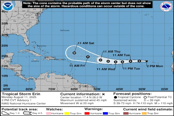
The forecast cone, often seen on maps from the National Hurricane Center (NHC), shows the probable path of the storm’s center over the next several days. It is based on official forecasts that incorporate multiple data sources, including satellite imagery, weather models, and observations from hurricane hunter aircraft.
Key points about the forecast cone:
- It does not show the size of the storm or where impacts will occur, only the probable track of the storm’s center.
- The cone accounts for forecast uncertainty, meaning the storm can shift anywhere within its boundaries.
- Hazards like wind, rain, and storm surge can occur far outside the cone.
What Are Spaghetti Models?
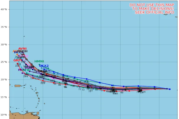
Spaghetti models are graphics that show multiple potential storm tracks generated by different forecast models. The lines resemble strands of spaghetti scattered across a map, hence the name.
These models come from various meteorological centers worldwide, such as the European Centre for Medium-Range Weather Forecasts (ECMWF) and the Global Forecast System (GFS). Tropical Tidbits provides a look at current active storm spaghetti models.
For more on interpreting the ECMWF weather model, check out our recent post!
Why spaghetti models are useful:
- They give an idea of forecast agreement or disagreement between models.
- A tight cluster of lines suggests higher confidence in the track, while widely spread lines show more uncertainty.
- They help meteorologists communicate possible scenarios, especially when the forecast is still evolving.
How to Use These Tools Together
The hurricane forecast cones and spaghetti models provide the official, most likely track from the NHC, showing a range of possibilities. Together, they offer a more complete picture of hurricane forecasting.
Tips for interpreting:
- Use the forecast cone for official guidance and evacuation decisions.
- Look at spaghetti models to understand potential changes and uncertainties.
- Monitor updates frequently, as forecasts can shift rapidly with new data.
Where to Find Reliable Forecasts
For the most accurate and up-to-date hurricane information, use trusted sources: