If you’ve ever watched weather coverage on TV or used an app to track a thunderstorm, you’ve probably seen a colorful radar map. While those red and purple blobs may look dramatic, they represent something very specific: radar reflectivity. But what do those colors really mean, and how can you use them to better understand what’s happening outside?
This guide will help you interpret radar reflectivity colors and use that information to become a more informed weather watcher.
What Is Radar Reflectivity?
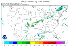
Radar reflectivity is a measurement of how much energy a radar beam bounces back after hitting precipitation particles like raindrops, hailstones, or snowflakes. The stronger the return signal, the higher the reflectivity value. This value is measured in decibels of Z (dBZ), with higher values generally indicating heavier precipitation.
The National Weather Service (NWS) and many weather apps use a standardized color scale to help visualize these dBZ values.
Common Radar Reflectivity Colors Explained
Here’s a general breakdown of what those radar colors usually mean:
- Light Green to Dark Green (5–30 dBZ): Light to moderate rain or drizzle. These values suggest minimal atmospheric activity.
- Yellow to Orange (30–50 dBZ): Moderate to heavy rainfall. This can indicate the need for caution if you’re driving or outdoors.
- Red (50–60 dBZ): Very heavy rain or possibly small hail. Storms with this reflectivity often come with thunder, lightning, and gusty winds.
- Purple and White (60+ dBZ): Extremely intense reflectivity. This usually means large hail, very heavy rain, or even debris in a tornado. Exercise extreme caution when you see these colors on radar.
Color scales can vary slightly between providers, but the general pattern follows this progression from light rain to severe weather.
What Reflectivity Doesn’t Tell You
It’s important to know that reflectivity only shows precipitation intensity. It does not tell you whether the precipitation is rain, snow, or hail unless the radar is in dual-polarization mode. Many modern radars are now equipped with this capability, and they can provide additional insights into precipitation type, shape, and even detect airborne debris in tornadic storms.
For more advanced radar interpretation, including dual-pol products, visit the NWS Radar School.
How to Use Reflectivity in Real Life
Knowing how to read radar colors can be extremely helpful:
- Tracking Storms: You can monitor approaching storms and assess whether they’re weakening or strengthening.
- Planning Activities: A quick glance at radar can tell you if it’s safe to go outside or if you need to prepare for severe weather.
- Emergency Awareness: In severe weather situations, high reflectivity values can alert you to take shelter or seek more information from emergency services.
Apps like RadarScope and websites like Weather Underground offer high-resolution radar with detailed color keys, which can help you become even more skilled at reading radar imagery.
Radar reflectivity is one of the most powerful tools for amateur weather enthusiasts. By understanding what the colors on a radar map represent, you can gain insight into what’s happening in the atmosphere right now. With practice, you’ll be able to spot potential trouble, stay safer during storms, and satisfy your curiosity about weather patterns.
For more beginner-friendly guides, check out other posts here on weatherhobbyist.com such as this one, where we explain how to interpret the ECMWF weather model, where we break down the tools and techniques used by meteorologists and passionate hobbyists alike.